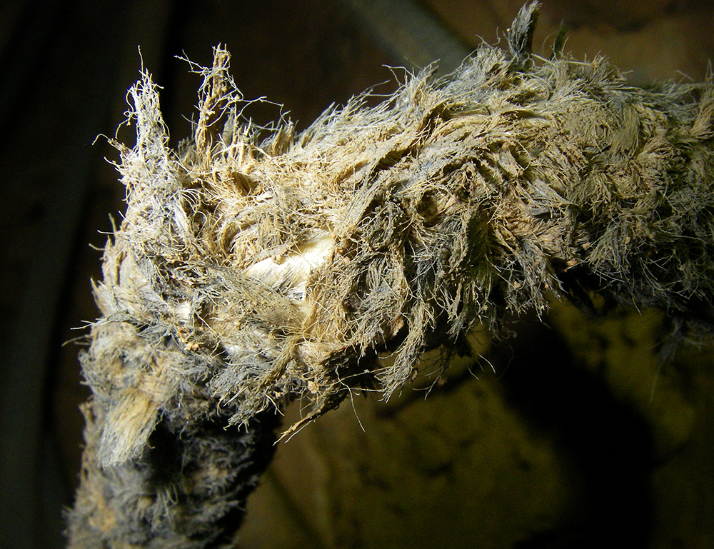
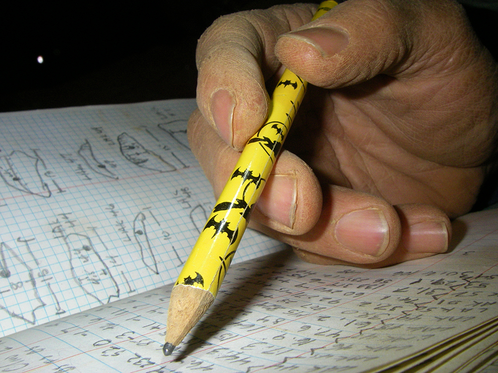
So on our way into Memorial Day Cave, we planed on replacing a rope that was very well worn. I found this core shot in it.
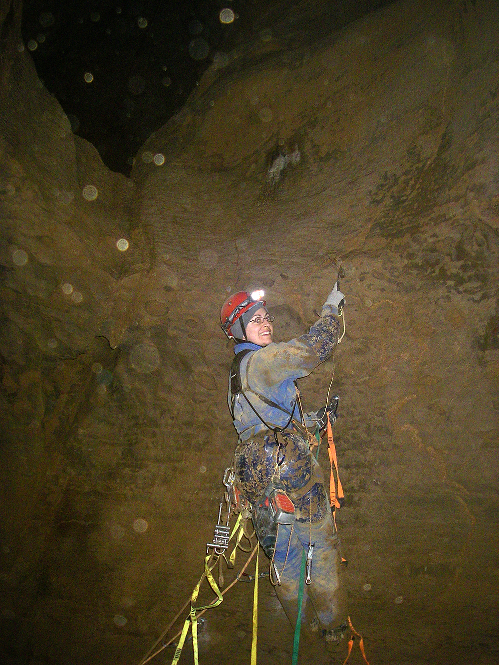
Heather Jordan was with us on the trip and was the first one to rappel down the replacement rope on the 50-footer.
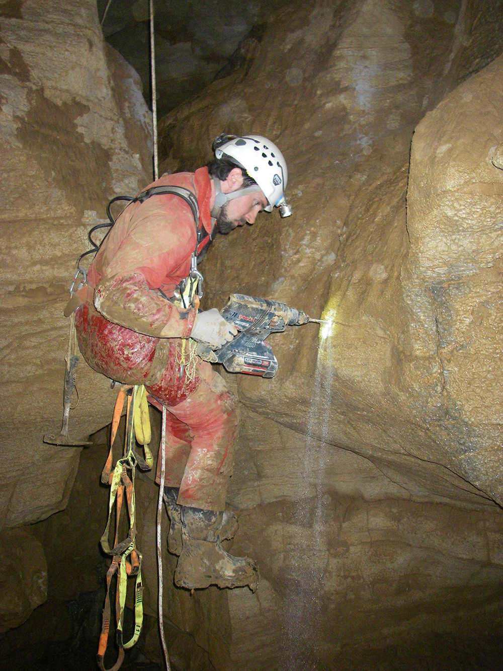
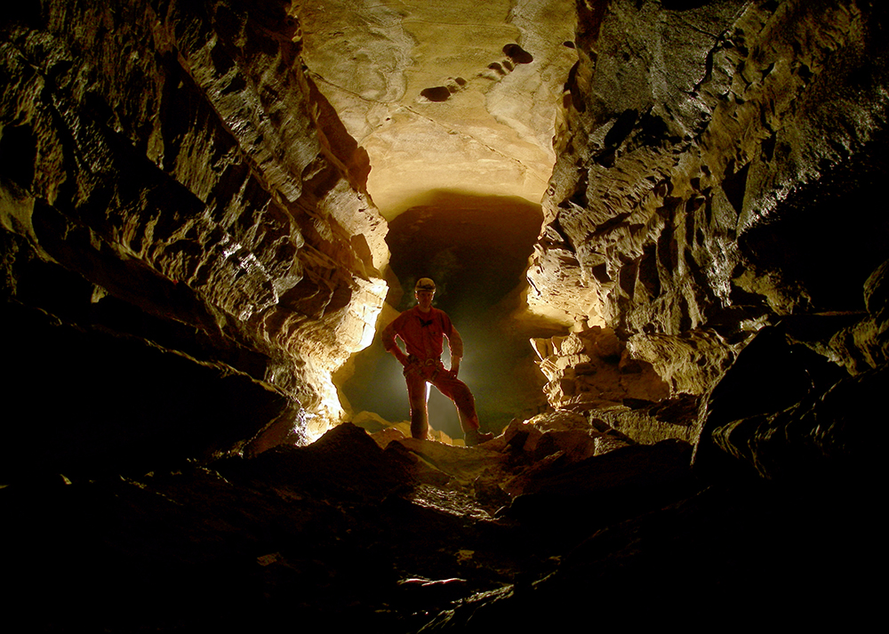
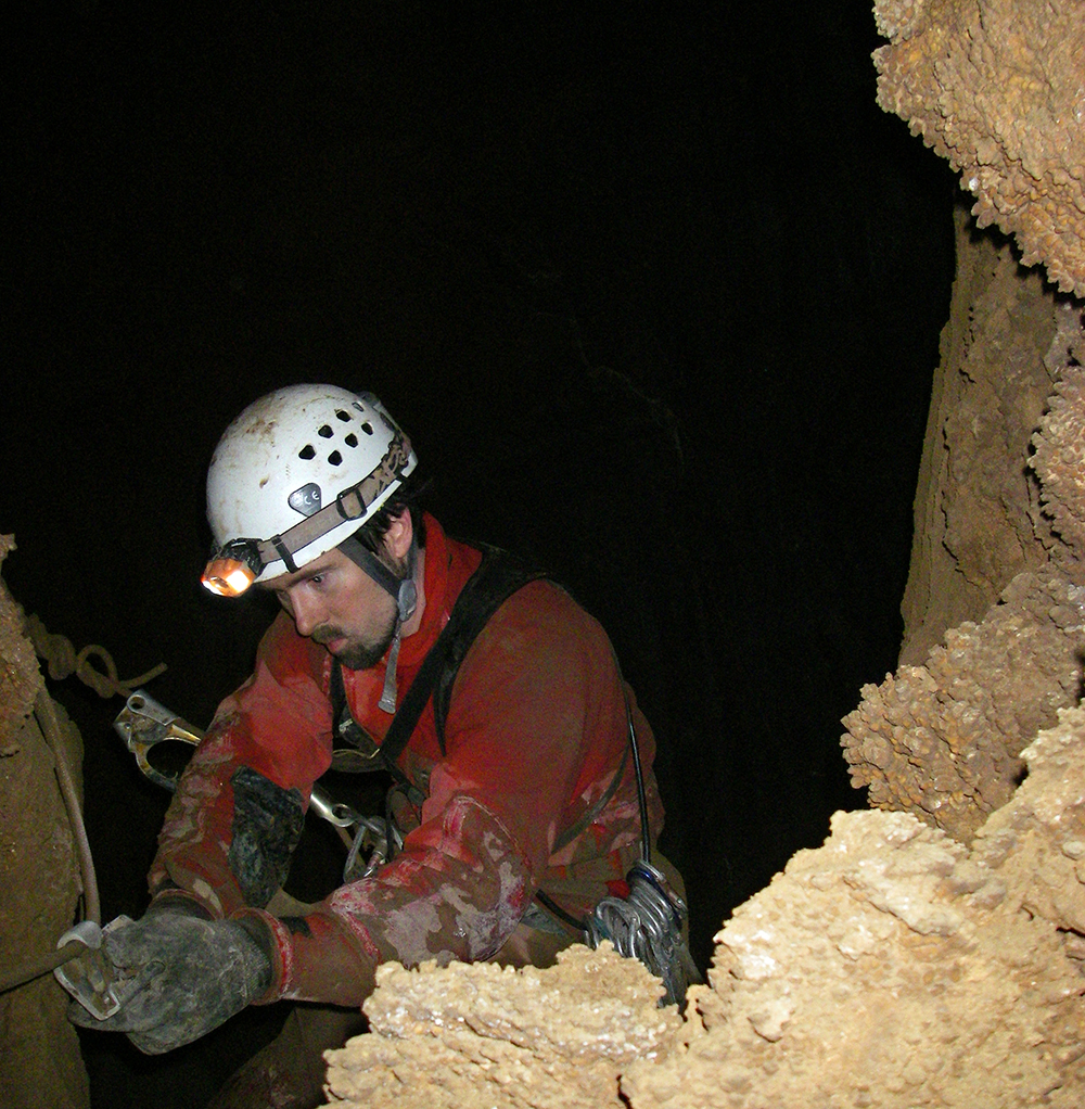
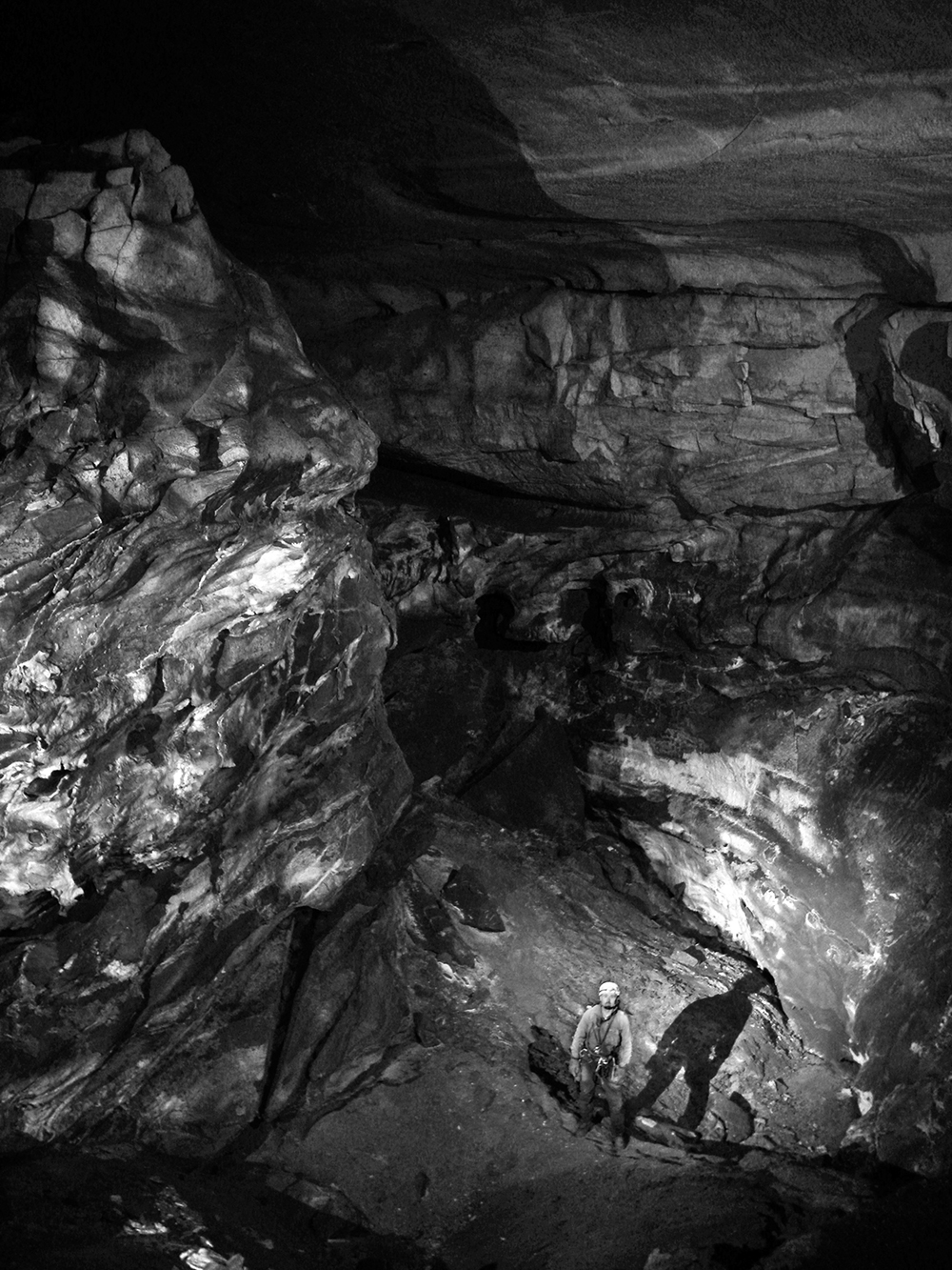
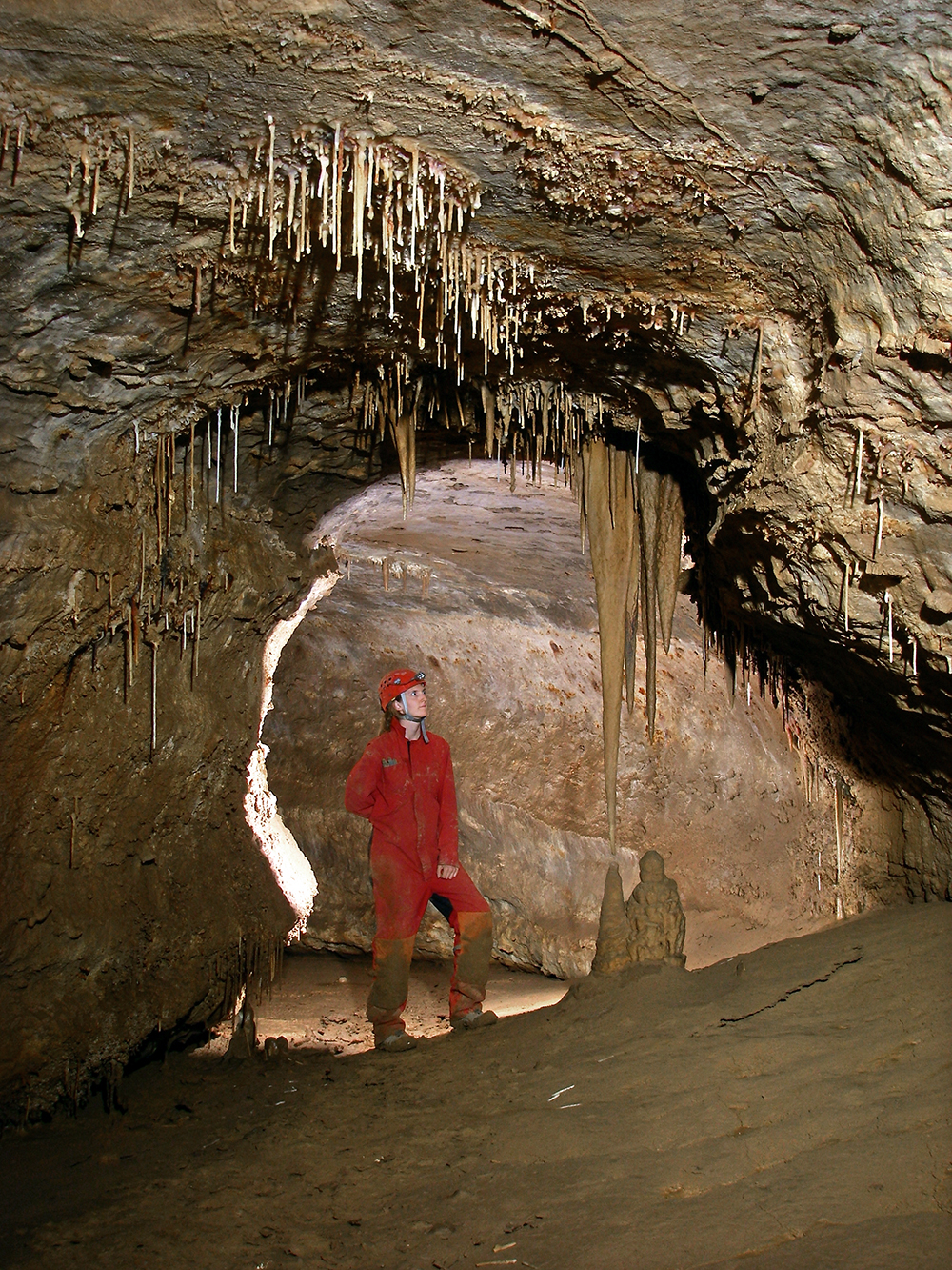
Here Chris bolt climbs up the small drop in the Cobble Room. Trip report below.
Memorial Day Cave Trip Report
Bolting Trip
June 11, 2011
by Nikki Fox
Saturday morning Chris Coates and I stopped by Stacy Waggy and Heather Jordan’s house to pick up Heather for our day trip into MDC. After breakfast at the Gateway, we swung by the field-house and dropped off the 1,000 feet of Highline minus the two short pieces we were going to use on the day’s trip. We got underground around 10:30 a.m., and our first goal was to replace the rope on the 50-foot drop before the Puppet Buster. The rope was in rough shape and needed to be retired. We had been keeping an eye on it and had noticed that there was a soft spot a little under half way down the drop that had been gradually getting worse over the last six months.
We had cut a 100-foot piece of rope for the job, which ended up being about 10-15 feet short, to replace the drop and traverse line. So we ended up using the current traverse line and replacing the main rope. We set aside the bad end of the rope on the ledge near the drop and I took some photos of the core peaking through the sheath in the soft spot. Next month, I plan on bringing the rope out so we can put it on the wall in the fieldhouse with the other bad ropes.
We then continued on to our lead in Ripple Way at a leisurely pace. The 400-foot crawl at the bottom of Fasten Your Seatbelts Pit was rather difficult with our muddy vertical gear and bolting items. We stopped to refill our water bottles at the watering hole along the way, which was flowing nicely this month.
After arriving at our lead Chris started his aid climb in the Cobble Room (LAL23) around 4 p.m. Once up, he rigged the short drop with the new 40-foot piece of rope and cleaned the route. Then I climbed first up to the passage and the rest followed. We caved for about 50 feet, which was trending upward in the curving passage until it got tighter. There were both muddy and clean-washed areas in the passage along with some air flow sucking into the cave. I took some photos and since I was not feeling very well and Heather was tired, we decided to wait until next month to survey and push the passage, with small thoughts in our minds.
The numbers:
No survey stations
16 hours underground
7 bolts (personal gear)
4 hangers (personal gear)
3 quick links (personal gear)
40 ft. 11mm rope (group gear)
100 ft. 11mm rope (group gear)
Terry McClanathan and Brian Young joined us in Memorial Day Cave, continuing the survey of Ripple Way.
Memorial Day Cave Trip Report
Mapping Leads in Ripple Way
May 14, 2011
LAL survey
by Nikki Fox
Chris Coates and I arrived at the Gateway for breakfast with a newcomer to the valley, Brian Young. Brian, a recent graduate from JMU, had never project caved. We met up with Terry McClanathan, our fourth in the team, at the fieldhouse. We went to the parking area where Terry got his usual head start into the cave. The rest of us followed, a little after 10 a.m. We got a little backed up in the Puppet Buster and again at the connection climb, but made it to our main lead in Ripple Way a little over 3.5 hours.
The first thing I noticed on our way in was the silence in the passage, which was loud last month with the rushing of tiny streams in Ripple Way. I was planning on refilling my bottle during the day and was beginning to become concerned with the lack of running water. Even near station LAK37, where Aaron and Terry refilled at the waterhole last month, it was dry.
Nonetheless, our first objective was to check the water level at the sump (LAK54). It was just as full, if not more. Which perplexed me since the water levels in the passage were obviously lower this month. We then traveled back to our first juicy lead: a northeast passage downhill at LAK47. Chris was on backsight again, Brian was on frontsight, Terry was sketching cross sections and book and I was concentrating on the main sketching. It took several shots before Brian got the hang of it, but once he did, we were good to go.
We made our way down the sandy hill, and then upwards again. It was small passage, we were sitting down most of the time. Between LAL5 and LAL6, we figured out that we were below the two small holes in floor at LAK41. “Rats!” I said, having two fun leads taken off the list to push in the future. Further up the passage we ran into a small standing pool of water (LAL9) with some nice formations. The passage went to a crawl through some sloppy mud and then we popped out into the Ripple Way! We tied in LAL11 into LAK39. In our 300-foot loop in a lower level, we had managed to take off three promising leads.
We then decided to go back and survey near the waterhole area. I was out of water, so while the others were eating lunch, I pushed my way through a small crack (going northwest) filled with tiny, grabby popcorn towards the sound of running water. I found a nice room with a 3-foot-deep pool being fed by a gush of water coming down a well. The water continued east down a small passage.
Upon my return, we packed up and started our second part of the survey for the day (LA12) from station LAK36. We followed a high crawling lead going north off the Ripple Way. It was there that Terry said to Brian, “Just be a man and shoot it,” after Brian complained about something. It was hilarious! After we proceeded forward in the passage, it quickly became apparent, with all the holes in the floor, that we were above the waterhole. We were about 20 feet above the floor. The area was covered in slick mud and several rocks fell below as we passed through the upper level. After three stations we were on the other side (LAL15), back safe and sound on solid floor.
We followed the passage, which was trending upwards, past a nice flowstone area with a large column (LAL16) and into a room (LAL 17). From here the passage turned southwest, following a floor channel with running water. This passage must have been gushing last month, to offer up a nice place to refill water down at the watering hole. Around station LAL21 the passage ceiling was getting higher, like a little canyon. At LAL23 we popped into a nice cobbled room. I’m just going to refer to this room as the Cobble Room. We shot down a smaller passage, which dead ended (LAL24). To the east, we could see another upper level continuing to go. This would require a short bolt climb, as it was only about 20 feet above the floor. We left another lead, it was at the top of the Cobble Room, going west. It appeared to have a lot of breakdown in the crawl. We then traveled back to the waterhole and surveyed the lower level, tying it into LAK37 and LAL14 above.
We made our way out of the cave, with Terry leading the way. It took us a little over 4 hours to exit the cave. We changed in the rainy night and made our way back to the fieldhouse for some food and sleep. And yes, we did turn in a waiver, Miles. I believe that Brian had a great time and will return to the Valley.
The numbers:
26 stations
635.1 feet of survey
16 hours underground
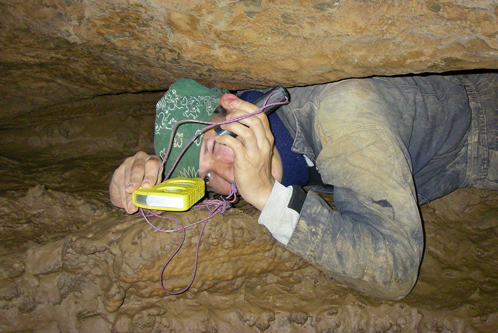
Here Brian Young reads instruments while taking a shot during the survey.
Had a fabulous trip into Memorial Day Cave trip with Chris Coates, Aaron Moses and Terry McClanathan!!
We continued the survey of borehole we found at the bottom of Fasten Your Seatbelts Pit. We spent 16.5 hours underground and surveyed nearly 2,200 feet of passage! Above is Aaron standing the the borehole we named Ripple Way.
Below is Terry doing the cross sections.
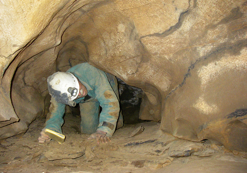
Here Terry comes out of a side lead.
And a photo of the sand that inspired the passage name — Ripple Way.
Memorial Day Cave Trip Report
The Push of Ripple Way
April 9, 2011
LAK survey
by Nikki Fox
Chris Coates and I met up with our crew — Aaron Moses and Terry McClanathan — for breakfast at the Gateway. Terry got underground first to get a head start. Chris and I were in next, in around 10 a.m., followed by Aaron. Aaron caught up to us when we were at the 50-foot drop. At the bottom, Aaron passed us to catch up to Terry, who we could hear banging around in the Puppet Buster.
We all made our way to the top of the connection drop. Aaron took Terry on a little tour of the upper Western Section, including showing the window into Nebraska Canyon and Starlight Passage, which Aaron had never seen himself. At the bottom of Fasten Your Seatbelts Pit, which took us 3.5 hours to get to, we all got rid of all or part of our vertical gear and started the long crawl to the borehole lead Chris and I did last month.
At LAJ15 we stopped, had a snack and decided who would do what. Chris did his usual duty as frontsight, Aaron did backsight, Terry recorded the data and sketched cross sections while I did the sketching. This provided to be most efficient, allowing us to survey the passage rather quickly.
There were 8 to 10-inch scallops on the ceiling with iron-colored rings along passage between LAK1 and LAK19. When Chris was setting station LAK8, Terry and I were at station LAK6. Aaron said there was a side passage on the opposite wall, so I crawled up the hole and went around a couple of turns, to see the small crawling passage going uphill with a floor channel in the bottom. It reminded me of the Puppet Buster. So I crawled back and hollered at the boys that we should survey it. Chris was not a fan of leaving the nice borehole. After 4 shots, Chris went a little further and found that it opened up into a small room and then continued in a crawl. We decided to leave the crawl as a lead for another time. Once back in the borehole both Terry and Aaron “bitched” about how aweful the borehole passage was to survey. This joke continued throughout the day.
Back in the main bore, we ran across another floor channel between LAK8 and LAK13. It originated from a tiny hole along the western wall and cut a huge slot in a mud mound. It was around this time the mud started getting a little gewy. After LAK13, there was a visible drainage area on the east wall, under a shelf, with the first collection of gravel we saw in the passage. The passage then constricted to a hands and knees crawl, where there were large sand mounds with wonderful ripple designs. Suddenly, we popped into a 13.5-foot high dome! At the bottom, there was a small crawling passage with cracked, sticky mud on the floor (LAK16). Before we went further, Chris returned to the beginning of our survey to retrieve our packs and I took photos of the mud cracks before it was destroyed by our path. The muddy sump turned out to be 9 to 11-inches tall the whole way and was 45 feet long.
After the sump, we crawled up a sand bank, again with beautiful ripples, and followed an old water channel up the passage, which started at LAK21 from under a rock pile. The passage from LAJ8 to LAK20 had more sand/mud mounds. It was at LAK19 when I heard a low-frequency pop. I said “It just sounded like something fell in the passage ahead.” Aaron quickly chimed: “No it’s not! That’s the Ruddle crew we’re hearing!” There was much excitement and hurry to push the passage further to see if there was a small crack somewhere in the passage where the Ruddle crew could connect.
Just around the corner (LAK21) the bore dramatically changed. The floor was covered in muddy breakdown and the walls looked craggy, not the smooth-lined walls with scallops we had grown accustomed to. I do not know much about the kinds of limestone in GV, but I would have to guess that we had entered a new contact layer.
We surveyed through the breakdown, hearing the familiar low-pitched drilling (from LAK22 to LAK27) we have heard working on the SEC connection dig. At LAK26 I found a standing pool of water. It was not big, and was about 6-inches deep along the western wall. Between LAK26 and LAK27 there was another gravel sump, but this time there was a trickle of water flowing down into it! Once the passage narrowed, to 5-foot tall (LAK 27), I could no longer hear the drill. So I went back, as all the others were ahead at least one station, and tried to determine where the drilling sound was the loudest. It seemed to be around this gravel sump.
We continued upstream and around LAK28 we started to see formations — lots of sodastraws and stalagmites. We popped into a wet, drippy passage that was decorated with flowstone and drapery. The passage branched off at LAK29. To the right (southwest) was upstream with air blowing. We continued straight (south), following the largest flow of air. After a small crawl (between LAK31 and LAK32) we climbed down into another junction room, accompanied with a small stream. The stream came from a breakdown pile (southwest) in the room, and traveled down the hill to the west. We left both of these leads and pushed forward in a dryer passage with no running water.
From LAK33 the passage became muddy. At several turns in the passage, we left three small crawling leads and a walking lead with running water near LAK37. It was here that Aaron and Terry refilled their water bottles. Between LAK38 and LAK39 we left a lead going southeast. It looked rather unpleasant — a wet, muddy crawl. Continuing along the passage, a very slick, muddy sloped had to be climbed to reach LAK39. At the top, we encountered another dry stream channel that disappeared down two small holes in the floor (LAK41). Up another small hill, a shelf jutted out of the wall (LAK42) and the passage became a stoop walk, for me. At LAK44 we came to a fabulous natural bridge with more scallops on the ceiling.
From here the passage had pockets of beautiful formations — mainly sodastraws, stalagmites and stalactites. Near LAK47 there was a very promising passage heading northeast down a slope. It has gobs of air and made me chilly sitting at the intersection. Around LAK51 the passage changed again. We followed a flowstone drain downwards to the end of our borehole. The entire area was covered in gravel and rotten flowstone. We stopped surveying at a water sump, which was 4 feet long, at least 6-inches deep and had at least an inch of air on the other side (LAK54). The good news is that it was blowing massive amounts of air. Our hopes are that this will eventually dry up for us. It was at the end of our survey that we discussed what to call the passage we had just mapped. Terry suggested “Ripple Way” and it stuck.
A big thanks to Aaron and Terry for joining us on our survey!
We couldn’t have done this kind of trip with just the two of us.
Side notes:
— Aaron seemed to think that the first stream was Ruddle water and the second was from Con.
— The air did change directions multiple times during the day.
— Took 4.5 hours to exit the cave from the last station
The numbers:
54 stations
2,171.9 feet of survey (0.4 miles)
16.5 hours underground
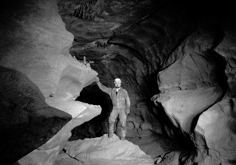
Chris stands at the spot where we stopped our survey of virgin passage in Memorial Day Cave. We pushed the tight crawl at the bottom of Fasten Your Seatbelts Pit and got 501 feet of survey.
Memorial Day Cave Trip Report
March 12, 2011
LAJ survey
by Nikki Fox
Chris Coates and I ate breakfast at the Gateway and then proceeded to get underground a little earlier, opting to skip out the meet-n-greet at the fieldhouse. We got underground before 10 a.m., and to the Bison Room in less than 3 hours. With our leads gradually being surveyed, our plentiful choices were dwindling. So we decided to survey the crawling lead at the bottom of Fasten Your Seatbelts Pit (57 feet). Our only time there was with Aaron Moses and Abby Hohn, when it was rigged, back in August 2010.
Typically, the crawl to the top of the drop has had massive blowing air coming out of the pit. That day, there wasn’t too much airflow. We rappelled in and I had forgotten what a nice little pit it was. We paused for a snack and then began the LAJ survey, starting from LAF13.
The crawl was a little tight at first, with the tightest constriction nearly 10 feet into the crawl, I’m guessing about 9 inches tall. But afterwards, the crawling wasn’t too bad. We did a couple of shots before we made our way into a little dome room (LAJ3), about 9.5 feet tall. There was a small offshoot from the room that did not go. The passage became small again until it opened up into a bigger dome room (between LAJ 3 & 6) with a ceiling height of 37 feet. We could feel the air blowing upwards while standing in this room. We think there must be a level above us, but it would have to be bolt climbed to see for sure.
Our next shoot, to LAJ7 provided to be an interesting feature in the passage. There was a little mud mound in the middle of the room, seem to be formed by a massive flood. Around the next bend, the passage started to open up a little, more hands and knees crawling. After we hit our third ceiling dome (near LAJ11), we decided to break for lunch. Chris and I had to crawl back to our packs, which we left at LAF13.
After a couple more shots up the passage we had run into borehole (LAJ12)! We surveyed another 133 feet in three shots before calling it quits. I was getting tired and having a hard time concentrating on sketching. We packed up and headed out at a leisurely pace of 4 hours.
The numbers:
15 stations
501.2 feet of survey
14.5 hours underground
Chris goes on the traverse to get into the middle of the Wet Happy Dome, where he bolt climbed to the top of a saddle during our project caving trip in Hellhole.
Hellhole Trip Report
Climbing the Wet Happy Dome
Feb. 18-20, 2011
by Chris Coates
Nikki and I left Harrisonburg after work on Thursday, heading over to Franklin to catch dinner before heading into SEC. While we were eating dinner Stacy, surprised us by tapping on the window of Foxes Pizza. Stacy, Heather and his dad came in and we all talked for a while. Nikki & I got massive belly aches and decided that caving would not be a good idea that night, so we slept in the Jeep.
In the morning we felt better and got the traditional greasy Gateway breakfast when they opened at 7 a.m. We went back to the field house and retrieved Lewis’s rope/bag, and bolts and left a note at the Harpers since no one was home. We entered SEC a little after 8 a.m., and headed to 2007 camp. Once there, we dropped off Lewis’s stuff and collected some of our gear to take to Last Falls Camp. During our leisurely pace we noticed that the water level was a few inches higher than in January. All in all, it was an uneventful trip except for when I tripped in the stream and went swimming with the drill and other gear. This made me chilled for the rest of our journey to camp. So when we arrived, we set up our bed, ate dinner and went to bed very early.
We got up around 5 a.m., and made our way to Diggers Hall to find and sort John’s climbing gear. In the crawl leading to Wet Happy Dome I geared up in the jungle of cords, webbing, rope, and misc crap. Of course the traverse into Wet Happy is a nasty gear grabber. I climbed down to a belay alcove on the right and set a good belay bolt. After we were all set up and untangled, I started a bolting traverse around the dome with Nikki on belay. Once at the back corner, I progressed up about 20 feet before running out of supplies. I came down and we ate lunch, regeared and started again. On the way through the crawl this time Nikki and I cleaned the entrance passage. It is now devoid of popcorn and is an easy hands and knees crawl with no grabbers. I continued the climb for another 30 feet to a saddle, which was out of sight from the belay alcove.
I needed more gear and Nikki was going to have to come up and belay me from a higher point from which she could see. Then we talked about what was needed she told me that her hands were tingly and she was having trouble gripping. Oh boy, just what you want to hear from your safety person. So we opted to finish the climb next month. So while she was packing up, I set another bolt to make a free rappel to the bottom of Wet Happy Dome.
I rappelled to the bottom and realized that everything thrown into the pit goes into a small puddle at the bottom. It is a true funnel. On one side of the bottom is a tight crack, through which I could crawl once I removed my vertical gear. The passage was tight, grabby and wet. On the other side of the crawl is a small loft with about a 30-foot drop going down into a small room. It appears to have a couple of small leads going off at the bottom. Otherwise, at the loft level on the far side of the room is another tight squeeze with what appears to open up into a room. When turning around to climb/crawl back to the bottom of the rope, I noticed a narrow chimney going down at about a 45-degree angle.
In summery, there are several promising leads at the bottom of Wet Happy Dome (Pigtail Pit is a name that Brian Masney used in his trip report to the pit on Jan. 21, 2011) that need to be pushed and surveyed. When I climbed up, I pulled the rope up out of the pit. It is still rigged, just piled in the entrance crawl to keep it from getting pulverized by any and all debris falling into the pit. Then we headed back to camp, dropping off the climbing gear where we found it.
Sunday morning we got up late since we had no alarm and headed out. One of Nikki’s ascenders broke on the morning of the first day and her back up ascender was severely worn out, which made for a long, frustrating trip back up through the SEC entrance series. Once out, we stopped by and chatted with the Harpers for about a half and hour. Franklin provided our dinner stop of Subway.
Notes:
— No Survey
— A lot of air flow going into the pit from the Dry Happy Room.
— From the saddle all the way to the bottom of the pit is about 110 feet. It is not free hang and there are two rebelays near the top.
— The rock is good dark grey with small veins of calcite throughout. There are calcite fossils sticking out all over the walls. The walls are very abrasive and sharp.
— The top rig point in the saddle is a single 3 3/4’” carbon steel bolt.
Here’s me on my first aid/bolt climb! Of course it is in our beloved Memorial Day Cave.
Memorial Day Cave Trip Report
Feb 12, 2011
Chris Coates and I met up with the GVKS crowd at the Gateway for a hardy breakfast. We went to the fieldhouse to dress in the warmth and cover from the cold wind gusts outside. We followed Terry McClanathan in, who got an early start since the rest of his team was delayed by snow. We caught up to Terry in the Puppet Buster and chatted with him for about a half an hour at the bottom of Columbia Canyon. We said our good-byes and went our separate ways.
First, our goal was to bolt climb up to an upper passage that connected two rooms (between stations LAG2 and LAB5). During our September 2010 trip, we made a light and voice connection between the two, but we wanted to make sure there was no passage above. Plus, this was a nice, short climb to learn how to bolt climb. With Chris on belay, he guided me through the steps of gear management. I was surprised at how easy it was to get into a rhythm of aid climbing. Granted, I had good, solid rock to work with. Unfortunately, about the time I was getting very comfortable with the process, my legs started to cramp up, which ended my climb after only five bolts. So Chris and I switched. With me on belay, he topped it out with three more bolts. I was unable to join him on the climb because he forgot to attach the static rope to him, where I had left it on the fifth bolt. I went to the other side of the upper passage, near LAG2 to check out the other side. Chris said there was no passage above. So he came down and cleaned the route.
We had a snack and then decided to go and bolt some of the drops in the crawling section. It was the first time we had been back in the crawl since the upper Columbia Canyon connection was made in July 2010. Chris put in two bolts at the slot in the floor near LAA6. After, we went to the small room that had several leads, We crawled through the hole in the floor, near FIS6, to access the most promising pit on our list. Chris again, worked on setting the two bolts and hangers while I passed him the tools as we both were lying down. We then made it back to the last pit with the clean-washed sides, near NAC1, off of the station FIS4. Chris wanted to be clipped into something while bolting this, and since we left our vertical gear and ropes back in the Bison Room, we opted to leave it for later.
After eating lunch, we inventoried our gear for our next task: to tackle the flowstone climb at the top of the CC connection traverse in the slit above LAE7. While I was on belay, he spent five bolts on the climb. The rock was not very good, and completely mud covered, as I can attest to a mud shower for the entire time. Once at the top, Chris was straddling a mud bridge looking down each side. It was not what we had hoped for: another upper passage. He rigged the tail of the rope used on the 72-foot connection drop and came down, cleaning the route. Chris thinks that there may be free drop into Columbia Canyon on the other side of the straddle.
We made probably the best time, ever, when heading out of the cave. This can probably be attributed to my pain of wearing my harness. I had an extreme urgency to get it off as soon as possible. Once out, we were greeted with cold, piercing winds and changed as quickly as possible.
The numbers:
14 bolts used (personal gear)
2 hangers used (personal gear)
2 mallions used (personal gear)
0 feet of survey
16 hours underground
Chris on rope, exiting Nebraska Canyon in Memorial Day Cave. The LAI survey Kevin Skelton and Christine Burton. Chris and Carl Amundson worked on a bolt climb at the western end of Nebraska Canyon. I took the others to work on the eastern end with the mud slope. Found the end, a tiny stream and a little pool of standing water.
Memorial Day Cave Trip Report
Surveying Nebraska Canyon
LAI Survey
Chris Coates and I meet up with the usual suspects at the Gateway for a hearty breakfast before entering MDC on Saturday morning. We were joined by Carl Amundson, Kevin Skelton and Christine Burton. We went to the fieldhouse to change, along with the other crews, wanting to avoid the frigid day and got underground a little after 10 a.m.
Once we were up in the western end, I took Carl for a quick tour of the upper level while the others were still making their way up the connection drop and the mud slope. I wanted to give him a quick tour and get him oriented. It still surprises me how we breezed through almost a mile of passage in minutes, when it took so long to map it.
We stopped for a snack near the Bison Room and then headed to the window into Nebraska Canyon. Armed with digging and bolting tools, we were on a mission to push the canyon on both ends with the two crews. Chris and Carl tackled the 25ish-foot bolt climb at the western end. I took Kevin and Christine to push the mud slope on the east side.
Upon scrambling over the breakdown choke at the bottom of the rappel into the room, I was soon presented with blackness, a black void plunging downward. Where was this slope? Kevin backtracked, and climbed into the breakdown. A short time after, he shouted that he was looking down a mud slope that looked pretty sketchy. He had found it. Christine and I followed suit and stopped to get out our digging tools. Between the three of us, we were armed with a mason’s hammer and three Wonder Bars.
The three of us worked on carving out steps in the mud slope to get to the bottom. We got to the bottom of the slope and it looked like the drainage for the canyon as we saw river rocks. I checked out a crack in the wall, and found running water. It was a tiny stream that ran parallel to the passage on the south side.
I then started to climb up the next mud slope only to be stopped by another breakdown choke in the passage. Here there were two tiny holes that barely looked passable. So I went first, and with the aide of Kevin, wrangled my way through one of the holes. I decided to go ahead and walk to the top of the hill to see what was beyond. Around a 150 feet later I made it to the top and pushed my way into a small room. It was the end of Nebraska Canyon.
Upon my return to the breakdown hole (LAI6) Christine was attempting to join me on the other side. With help, she also made it through the hole. Kevin decided to try next. He wiggled, but could not make it. So he rested for a bit while I made some adjustments to the hole with his hammer. He then tried again and made it. We all went to the end and then started the survey back.
The tiny room at the eastern end (LAI1) had a small lead. It looks like a drainage route that goes into the canyon. It’s small and not passable without persuasion with no air flow. Above LAI3 there are cracks with multiple fissures in the ceiling channel, which pretty much spans the entire canyon. A possible bolt climb? It will perhaps lead to nothing… but I would like to know how far Neb Canyon is from the surface.
Upon our survey back to the rope, Chris and Carl caught up to us. We heard a huge collapse and learned that they dislodged some of the rocks in the breakdown choke to widen the vertical hole (LAI6) we all pushed though. When Kevin first saw it his rightful response was, “Now that’s cheating!”
When we made it back to the little stream at the bottom, Chris and Carl were busy pushing all the leads there. They found that the tiny stream passage is passable and leads to several tiny rooms and keeps going. We did not survey this because it was getting late. Chris and Carl also removed some rocks on the northern side to access a tiny crawl way. At the bottom was a pool of standing water. To each of our amazement, we each took a turn down there dropping small rocks into the water and watching them disappear into darkness. Carl rigged up a way to measure the abyss, which I wanted to call the Ogallala Aquifer. (Getting a little carried away with the theme of the western section of the cave…) He used a Wonder Bar, a small biner and the tape. He dropped it down the hole and to our disappointment, it ended up only measuring 9 feet deep. We figured out that the lowest point n Nebraska Canyon to the the ceiling is roughly 140 feet.
We surveyed up the canyon back to the rappel and tied the survey in. On the way out, Chris and Carl replaced 10 of Aaron’s personal carabiners he used for rigging on Nebraska Canyon and the connection drop/traverse with our own stainless steal mallions.
On a side note — Christine found a Wonder Bar while walking in Nebraska Canyon. I can only assume that it was accidentally left there from one of people during the LAD survey last July. Which means that it belonged to one of the following: Abby Hohn, Aaron Moses, Peter Penczer or Pete Johnson. In any case, it came in handy, so thanks mystery person! It should also be noted that it was accidently left near the water we found (between LAI6 and LAI7) in Nebraska Canyon. It seems that the Wonder Bar does not want to leave!
The numbers:
12 stations
373.2 feet of survey
18 hours underground
It appears that we have found the deepest point in the cave with our LAI survey!
Chris Coates stands in Hellhole’s Back In Business Borehole.
We had a 3-day cave/camp trip into Hellhole via SEC with Dwight Livingston and Aaron Moses.
Here Dwight looks at a delicate gypsum pigtail coming out of the wall where were surveyed.
Hellhole Cave Trip Report
The Happy (HPY) Survey
Dec. 31, 2010 to Jan. 2, 2011
Participants: Chris Coates, Nikki Fox, Dwight Livingston and Aaron Moses
Dec. 31, 2010
Chris Coates and I started late Friday and subsequently got underground a little before noon on Friday, the last day of 2010. Armed with 2 packs each, we made it down the SEC entrance series into Hellhole in the slow pace of 3.5 hours. We went to the old camp to drop off and pick up supplies before heading to the new camp near Last Falls in the Silent Stream passage. We timed ourselves from the old camp to the new camp: 5.5 hours. We showed up to camp a little after 10 p.m., to a sleeping Dwight and Aaron. We chatted a little, then set up camp using Mark and Vonny’s sleeping gear (thank you!), made dinner and went to sleep. As a side note — I did not sleep very well due to the constant noise made by the little falls in the stream right next to camp. I wish I had ear plugs!
Jan. 1, 2011
Saturday we woke up bright-eyed (well, some of us) and bushy tailed ready for a day of survey! We were at Aaron’s bidding since neither of us had been down there before and didn’t know where to go or what had been surveyed. First on the list was to check out a lead at the top of Digger’s Hall. After a sandy crawl, we were standing atop breakdown choking the passage of a ledge. Aaron rigged a short rope and we all rappelled the 20 feet or so down the vertical passage. Dwight did the book with the GWD survey of this high ledge series. After we could go no further without the aide of bolting gear, we left and entered Back In Business Bore.
Aaron lead us all the way to the upper dark-colored breakdown area, right before the crawling towards Ecstasy Avenue. Chris and I went down a tight side lead that was on the southwest wall, trending south between ZFF1 and ZFF2. It did not go far, maybe 30 feet before ending. We did, however, stumble across a nice pile of gypsum needles. We then proceeded to go back northeast in Back In Business Bore to clean up some side leads. Aaron and Dwight looked into a lead between ZFE17 and ZFE18, while we took a small lead near ZFE15.
The HPY survey entered in a small crawl and then opened up into a beautiful, smooth passage in swiss cheese. It was very 3-dimensional and I was having a difficult time sketching all the holes in the ceiling and the passage. Between HPY4 and HPY5 there was a natural bridge created by a hole in the passage, very cool. I’m sure that Aaron, who was working on profiles once he and Dwight caught up with us, was having a hard time drawling as well. At HPY5 two sister pits plunged downward about 15 feet. The larger one on the left is free climbable.
Once in this lower passage, we were standing on gypsum sand littered with needles. We eventually made it into a large room, which I call the Happy Room, with the dome ceiling measured at 92 feet. A ledge can been seen before the very top, which measured at 88 feet. This could possibly be climbed in the future to see if there is passage above that goes, but I would not deem it a priority. The room seemed to end, but Chris found a small hole along the western floor that went down to another level. Chris and Dwight fetched vertical gear and rope, which was left in Back In Business Bore. Aaron rigged around a hole in the ceiling and rappelled down the 50-foot rope into the pit. He came back to the Happy Room and reported that the rope was too short for the drop and that the pit was washed clean. He also said that there was a dome climb to reach the top. Chris took measurements with the disto, and it was determined it would indeed be a 100+ foot pit once reaching the top!
We surveyed the rest of the passage trending north from the pit. The passage was a gypsum dream — we were surrounded by fluffy white clusters, 5-inch needles, curlicues, frost and other formations I’ve never seen before. (Photos will be sent to Lewis for posting in a couple of days/months). We called it a day, leaving the pit lead for a future trip.
Back at camp, we all toasted in the new year with mini liquor bottles that Chris and I brought. We ate our dinners and then all shared some raspberry chocolate crumble for desert. It was a fine day to bring in the new year!
Jan. 2, 2011
On Sunday morning Aaron and Dwight were in a hurry and left around 8 a.m. Chris and I, who were more leisurely, left camp around 9 a.m. We had to go back to the old camp, to again exchange gear, and take inventory. It took us 3.5 hours to get from one camp to the other. We arrived to the warm sun, with eyes hurting, at 4:30 p.m.
The numbers:
20 stations
288.2 feet of survey
53 hours underground
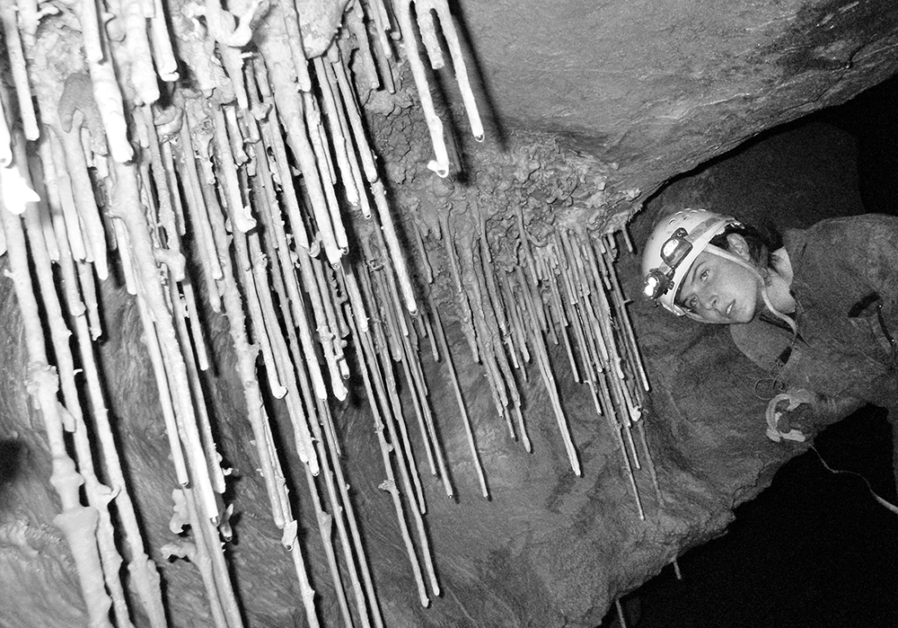
Abby Hohn admires a row of 2-3 foot-long soda straws in the Starlight Passage of Memorial Day Cave during a survey trip.
Memorial Day Cave Trip Report
Tightening Loose Ends
Chris Coates and I met up with Abby Hohn at the fieldhouse on Saturday morning for more surveying of the western end of Memorial Day Cave. With Abby’s Sunday work schedule and me just getting over a 2-week stent of loosing my voice and having congested lungs, we pretty much decided before entering that our trip was going to be a short one in comparison to our previous trips, which often averaged 16 hours underground.
Our destination was to return to the Starlight Passage and continue surveying the borehole that we abandoned due to time in September with Kurt Waldron and Heather Jordan. I brought my camera again to get some photographs (love the new big pack). Abby and I worked on making some images while Chris started the survey sheets. Chris wanted to learn how to sketch, so after I gave him a crash course and some pointers the night before, he was on his own. Unfortunately, I did not work as efficiently with Abby as Chris usually does. Several times he had to reshoot a shot for us, which slowed our survey down.
After 200 feet in the Starlight, the passage pinched down and beautiful white sodastraws grew everywhere. There were a couple of massive sodastraw piles in the passage. I’ve never seen huge piles like it before! The passage appeared to continue ahead, so I pushed the crawl. I had to dig the floor out and push the muddy gravel aside to continue forward. I was trying to reach a spot that looked like it opened up and possibly took a left. After about 20 feet I reached this “room,” which turned out to be nothing more than a tiny space that was 1.5 feet tall, rather than the 6-inch-tall crawl I was in. I made the station LAH5 in this little room. I did not bring my instruments with me in the crawl, so Abby just shot twice from LAH4. I tried to turn around in the small space, but was unsuccessful after several minutes of wrangling about. Finally, I had to give up and back out of the crawl. When looking further into the small passage, it is hard to tell if it kept going or not. It does pinch down pretty small. One thing for sure: that if someone wanted to push it, digging would be involved.
So after we pushed the main Starlight Passage to the bitter end we decided to stay in Starlight and push the other multiple leads we passed by. The first one we tackled was a crawling lead near LAG21, which was going north. When hunching down and looking into the passage, it looks very promising and large. Upon entering, you crawl over very muddy breakdown into a small room where we made station LAH7. From here, heading northeast, the passage quickly tapers down into another crawl. Only after a couple of shots I was again in a tight crawl where I could not turn my head. Again, I placed a station (LAH9) and Abby had to shoot the frontsight twice because I could not move. The passage continued, only to get smaller and smaller. There was a little air, but not much. Back at LAH7, we crawled up a slope and found ourselves back into the Starlight Passage. We tied into the LAG19 station on the opposite wall because LAG20, which was on the left, could not be easily seen.
We walked back east through Starlight, down the large muddy slope to our next lead: the northwest stooping passage at LAG15. Again, this passage looked very promising. It was sloppy muddy with more breakdown. I found little rat footprints all over the passage, as last spring in the original crawling route to the western end. I documented a few of them with my camera before anyone else entered, knowing they would be instantly destroyed. After station LAH12, the passage tightened and for the third time of the day I was in a tight crawl. I had to take my helmet off to push past a ledge sticking out of the ceiling. The smaller the passage got, the more decorated it became with sodastraws and helictites. I made the last station at LAH13 again unable to make a shot due to the position I was in. The passage, which was about 10 feet wide, turned in a hard right and shrank to about 5-6 inches tall. It was highly decorated and continued. I could not see and end. I retuned to Chris and drew the passage in the sketch.
It was about 6 p.m. and we were going back to the Bison Room for a snack before heading out. En route, we passed by a lead we decided to check out at LAG12. It was a walking lead going southeast, which turned out to be a mud hole. It was a challenge to stand up and not slide around while making our shots! After making a couple of turns, it became tighter to a hands-and-knees crawl. Around station LAH16 I noticed a hole in the floor on the left-hand side. I dropped a small rock down, and could tell this was a significant pit! Looking through the hole, I could tell that we were crawling on a false flowstone floor above this pit. I was not too happy about this and pushed ahead, only to notice a rope hanging from the ceiling. It appeared we made a connection to the top of Fasten Your Sealtbelts pit! Once we tied the survey into LAF4, we made our way back to the Starlight Passage to connect in another hole in the floor. We tied in LAH15 to LAG11. Then we finally made our way back to the Bison Room for a snack.
We started heading topside around 8:30 p.m. Abby took the lead out, as Chris and I followed. I was moving at a really slow pace since I was having trouble breathing. We caught up to her at the 125′ climb out of Columbia Canyon, but from there she scooted out rather fast. She was already gone at the fieldhouse when we showed up, on her way back home to Morgantown for work Sunday.
The numbers:
17 stations
579 feet of survey
13.5 hours underground
Here Heather Jordan looks at the awesome formations in the Memorial Day Cave’s Starlight Passage.
Memorial Day Cave Trip Report – the LAG Survey
by Nikki Fox
We met for the traditional breakfast at the Gateway to meet a rather small crowd, compared to the previous month. Chris and I met up with our team — Kurt Waldron and Heather Jordan. It was both their first time into MDC. We preceded to the cave and got underground around 10:30 a.m.
We made it to the western upper level by the new route Aaron rigged the month before: the CC connection drop. First order of business was to tie a handline on the very muddy slope in the LAC/CC connection room. I tied a couple of foot loops in the bottom so I could get on the slope without aid. We stopped for lunch at the Bison Room before starting our survey. Our plan was to survey the left borehole passage from the Bison Room since we were sans drill.
With our group of four, Chris remained on backsight the whole time as Kurt and Heather switched on and off on foresight. Heather helped me with measurements for profiles, which was nice for a change.
We found the small holes in the floor that Abby tried to connect to LAB5 in June. It was a small room we surveyed at LAG5. Between stations LAG2 and LAG3 there was a high lead that went southeast. I had a hunch that it would connect to the same high lead that looked like a bolt climb from the LAB5 room when we first discovered the big passages. I sent Heather to the LAB5 room and we made a voice and light connection.
We continued the survey from LAG2, which had sister beautiful domes that I measured at 50 and 70 feet tall. We went under a natural bridge from LAG6 to LAG7. In this next room there was a cluster of soda straws and stalagmites in one corner. Around the bend it got small and our hopes were dwindled with a small crawl. But Chris found that it opened up again into nice strolling passage.
Around LAG11 there was a hand-sized hole in the floor on the left. Chris threw a rock in and it went down for quite a ways. At the next station, LAG12, there was a passage trending to the northwest. We did not push it. As we went further, the floor was getting quite muddy.
After LAG13 the passage kept trending west. Between LAG15 and LAG16 there was a rather large mud slope, which will need some steps carved if there is much more traffic, with a huge passage going northwest. We left it and continued straight. From here the passage changed. There were white calcite veins on the ceiling, everywhere. Tiny needles also covered the floor. Station LAG17 was made on some beautiful stalactites. We named this passage the Starlight Passage as the walls seemed to twinkle with out headlamps.
At station LAG19 there was a left stooping lead going south. Chris and Kurt checked out this lead when I was taking photos one time. We did not survey it. After LAG20, there was another lead, going north, that we did not check out as well. At LAG21, another lead. This time it was crawling, not walking or stooping.
Between stations LAG21 and LAG22 the passage started to get really decorated with soda straws and helacites. And then the formation mother load: a beautiful stalactite over four feet long almost touching it’s sister stalagmite. I brought a couple of flashes and a few bulbs with me this trip (a new big pack = more room for stuff like photo gear). Heather was gracious enough to pose for some photos. The images from this trip are already posted on the GVKS site.
It was getting late, around 9:30 p.m. So we all looked at the decorated passage for another 30 feet or so and I took a bunch of photos. We retreated to the Bison Room to have a snack and then proceeded to head out around 10:30.
I think that Pete Penzer will have to visit the Starlight Passage and judge for himself if it’s the prettiest passage of MDC or not.
The numbers:
22 stations
731.2 feet of survey
16 hours underground